
Historic Preservation in New Orleans
Over the course of her career, Florestine Perrault Collins operated studios in several locations under three different names in New Orleans. She first entered the world of photography as an employee. She worked as a clerk, photo finisher, stationary embosser and developer for several independently owned studios and the Eastman Kodak Company. In 1920, she became the employer. She opened her own studio, called Bertrand’s, in the living room of her St. Peter’s Street house. In 1923, she relocated to North Claiborne Avenue, where she photographed Creole friends and neighbors in a dedicated commercial space that she eventually renamed Claiborne Studio. In 1935, she made the strategic decision to move her studio to South Rampart Street, the historic Black business and cultural hub in New Orleans. Under the name Collins Studio, she remained on South Rampart for almost 15 years before retiring to Los Angeles.
Reconstructing the places that Collins worked helps us understand the importance of her photography studios to the local community.

Put yourself in the shoes of a high school girl at McDonogh No. 35. Like many of your peers from downtown wards, you take the bus and make your way down South Rampart every day to get to school. You pass by Dix’s Barbershop, Pelican Billiard Hall, Morris Music, and, of course, Collins Studio. Jazzy rhythms echo in the air and while you don’t have time for a photo right now, you and your friends will be back over the weekend.
After church on Sundays, you and the girls take the streetcar to Collins Studio to get your pictures made. For a small charge, your photograph would be painted by hand, a special touch of color. You give your picture to a friend. Years later, she still has it, a treasured memento.
Collins’s customers wandered into her studio after a stroll on Canal Street or after a show at Loew’s State or the Orpheum. Taking a trolley into the city on the weekends, her studio was often busy with WWII servicemen and their girlfriends. The studio was also patronized by women-run schools such as Martinez Nursery School and Elma Moore Booker’s Dancing School. Collins photographed students dressed up for school pageants and graduation ceremonies.


Story Map
Current Conditions
Unfortunately, none of Collins’s studio locations are still standing. Construction and development projects have resulted in the demolition of not only Collins’s photography studios, but also the surrounding businesses and neighborhoods significant to the Creole and Black communities of New Orleans.
North Claiborne Avenue
For over a decade, 610 North Claiborne Ave was the location of Collins’s second studio. The site was destroyed in the late 1960s to permit the construction of the Interstate 10 Claiborne Expressway:
“Steel reinforcing rods now occupy the spaces where the roots of live oaks once spread, concrete pillars replaced their trunks, and the shadow of the interstate highway now towers above the neutral ground where generations of families used to walk to work, interact, picnic, and socialize.”
– Claiborne Avenue History Project Website

Claiborne Studio, the Negro Musicians’ Union, Steve’s Restaurant, Club 77, and St. Nom de Jesus Church are significant sites that served the African American community in 19th-century New Orleans. The music venues, eateries, pharmacies, and religious spaces on North Claiborne now exist only in memories and photographs.

While landlords on North Claiborne received payouts during highway construction, African American renters were pushed out and given nothing in return.
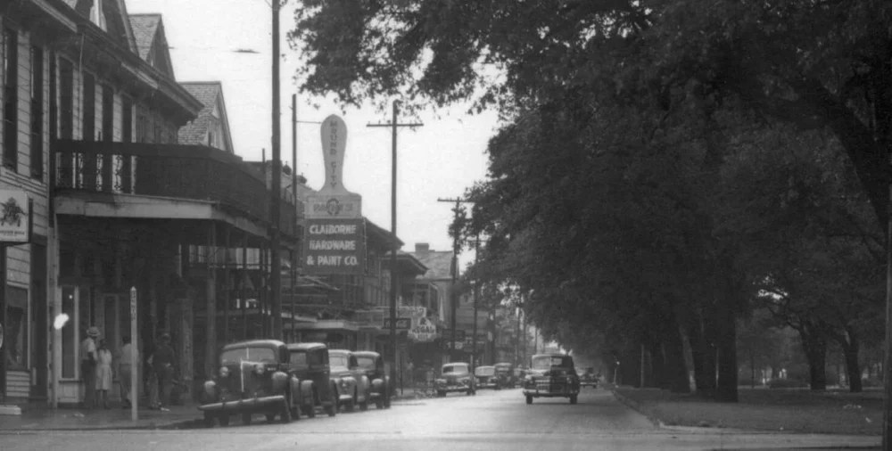
South Rampart Street
Many of the buildings on South Rampart Street suffered a similar fate. Parking lots have replaced historic businesses, as happened on 157 South Rampart, where Collins once operated her studio.


The dance halls, juke joints, clothing stores, and social clubs on South Rampart, which served the Black community, were run primarily by Jewish, Italian, and Chinese merchants. After over 15 years of debate, and against the wishes of preservationists and historians, the complex, which housed several historic black businesses and entertainment spots, was razed and replaced by parking lots and a garage.
Community Preservation
In some cases, where historic buildings, neighborhoods, and histories have been destroyed, community groups have stepped in to fill in the gaps. The Claiborne Avenue History Project (CAHP) is one such group collecting data, interviews, property research, newspapers, and academic papers on the history of North Claiborne Avenue. Their goal is to make this information publicly available.
“CAHP seeks to address and redress these ever-present wounds by capturing and transforming today’s human stories behind N. Claiborne Avenue’s history and weaving these voices into our multi-platform interdisciplinary project creating a community of voices to deepen a collective understanding of what it means culturally to be connected by a physical geographical space for over two hundred years.”
– Claiborne Avenue History Project Website

Image Credits
StoryMap
- Canal Street, the Main Thoroughfare of New Orleans, La (Detail), unidentified photographer, c. 1901, stereograph, https://www.loc.gov/item/2002717143/.
- Camp Street, New Orleans, La (Detail), photograph by Detroit Publishing Co., c. 1906, dry plate negative. 8 x 10 in. https://www.loc.gov/item/2002717143/.
- Canal Street at Night, photograph by Homer Emory Turner, 1947-57, kodachrome photograph, 1 x 3/4 in, The Historic New Orleans Collection. Gift of Beverly Turner Lynds.
- Portrait of a young woman and boy dressed in white (Detail), photograph by Florestine Perrault Collins, c. 1920-1928, 5 ⅞ x 3 ¼ in, The Historic New Orleans Collection, 2001.79.7.
- Collins and Friends in Front of Bertrand’s Studio, unidentified photographer, mid-1920s, courtesy of Dr. Arthé A. Anthony.
- S. Rampart & Common Streets, photograph by Charles L. Franck, 1930, The Historic New Orleans Collection, 1984.218.123.
- South Rampart Street between Canal Street and Common Street, photograph by Morton Dawson, 1944, 7 ½ x 9 ½ in,,The Historic New Orleans Collection, 2010.0150.8.
- Up North Galvez Street from 1300 Block, photograph by Charles L. Franck, 1947, gelatin silver print, The Historic New Orleans Collection, 1979.325.5301.
- McDonogh No. 35 High School, 635 South Rampart Street, photograph by Charles L. Franck, c. 1920-1930, gelatin silver print, The Historic New Orleans Collection, 1979.325.1870.
Image Slider
- Photo of Theodore “Teddy” St. Leger at around five years old, photograph by Florestine Perrault Collins, 1940, 5 3/8 x 3 3/8 in, The Historic New Orleans Collection, 2001.79.6.
- Unidentified merchant marine, photograph by Florestine Perrault Collins, early 1940s, courtesy of Dr. Arthé A. Anthony.
- Unidentified girl dressed for graduation from the Martinez School, photograph by Florestine Perrault Collins, 1940s, by permission of Numa Martines, courtesy of Dr. Arthé A. Anthony.
North Clairborne
- Up N. Claiborne at Ursuline (Detail), photograph by Arvin Frank Pelle, 1947, Charles L. Franck Studio Collection at The Historic New Orleans Collection, 1979.325.5135.
- 610 N Claiborne Ave, Google Maps, November 2024, retrieved Jul 22, 2025, from https://maps.app.goo.gl/qLoN5DLEVP4vPfNs6.
- Leah Chase Interview [01:21:56 – 01:23:44], Claiborne Avenue History Project, from Global Highways, https://cahpexhibit.georgetown.domains/exhibits/show/global-highways/four.
- Claiborne Overpass Construction, photograph by William Russell, 1968, 9 x 8.8 cm, William Russell Photographic Collection, William Russell Jazz Collection, MSS 520, Williams Research Center, The Historic New Orleans Collection.
South Rampart
- Down South Rampart Street along 100 Block, photograph by Charles L. Franck, 1946, Charles L. Franck Studio Collection at The Historic New Orleans Collection, 1979.325.5496.
- 157 S Rampart St, Google Maps, October 2024, retrieved Jul 22, 2025, from https://maps.app.goo.gl/SERQ23Y7xs6tDnmk9.